|
SD ID: ENVRI Radiative Forcing Integration Organisations & Contacts: Werner Kutsch, Alex Vermeulen, ICOS ERIC Ari Asmi, ENVRIplus, Paolo Laj, ACTRIS Stefan Kindermann, IS-ENES2 (DKRZ) Sylvie Joussaume, Sébastien Denvil, IS-ENES2 (IPSL) |
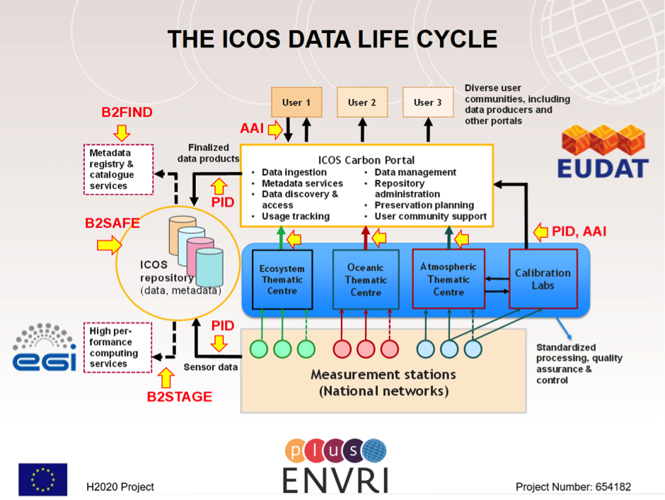
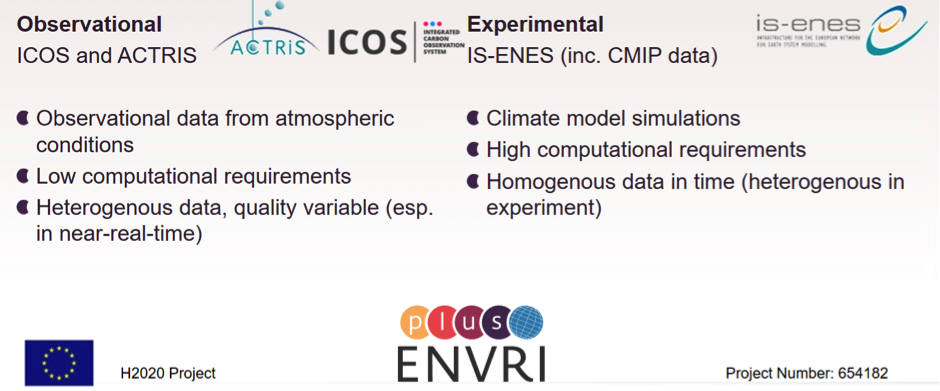
OVERVIEW: The environment-related disciplines provide many challenges around data management - both in terms of data size, data diversity and data distribution. The ENVRI Radiative Forcing Integration science demonstrator focuses on the interoperability between Observational and Climate Modeling Environmental Research Infrastructures. The scientific focus (redefined in the course of the project) addresses the generation of forcing fields for land surface/ecosystem models from climate models output (instead of the originally planned investigation of radiative forcing), while the technical objectives concentrate on:»the improvement of data integration services based on metadata ontologies»model-data integration by use of HPC»innovative services to compile and compare model output from different sources, especially on semi-automatic spatiotemporal scale conversion.
SCIENTIFIC OBJECTIVES OF THE DEMONSTRATOR:
On the practical side, the demonstrator estimated the capacity requirements to connect the IS-ENES2 climate data infrastructure with the in-situ data systems and land-surface modelling environment of ICOS. . The aim is to provide interactivity, i.e.land surface modelers can get relevant data from a number of climate simulations and generate forcing fields for their models from then, and int turn compare their simulation results with the experimental data collected by the ICOS Carbon portal. This demonstrator will also involve processing on spatiotemporal scale corrections.
TECHNICAL FOCUS:
- Improvement of data integration services based on metadata ontologies,
- Model-data integration by use of HPC,
- Petascale data movement,
- Innovative services to compile and compare model output from different sources, especially on semi-automatic spatiotemporal scale conversion
FAIR CHALLENGES:
- Findability: Metadata ontologies matching between NETCDF-CF and in-situ metadata, data quality indicators.
- Accessibility: Automated access routines between the RI repositories. For fully open data, this is not immediately problematic, but might require analysis on needed resources and APIs.
- Interoperability: APIs, service integration, large data transfers, where to do processing (how to document?)
- Reusability: Citing and persistently identifying scale-changed data-sets? How to transfer knowledge of data versions used.
ADVANTAGES:
- MATURITY: All participating RIs have existing data systems, and their “act together”
- INTERDICIPLINARITY: The case provides direct interdisciplinary activity (even though inside the environmental domain)
- SYNERGY: This action directly uses the connections and needs of the existing RI actions within the cluster project ENVRIplus
- ENGAGING COMMUNITY: The case is actually useful for the scientist (and RIs) in the field! It is not just a demonstrator!
MAIN ACHIEVEMENTS
In EFRI scientific use case a virtual platform in EGI cloud was used to run land surface model using climate model data outputs from IS-ENES data infrastructure. Land surface model LPJ-GUESS was used to simulate water and carbon fluxes and simulation outputs were compared to in-situ measurements from ecosystem flux towers (Fluxnet 2015 data set).
RECOMMENDATIONS FOR THE IMPLEMENTATION
Solving technical problems related to building a virtual platform for the analysis consumed more time than expected. Therefore, improvements regarding the interoperability and data integration was not achieved to the desired extent. Experiences from this pilot might be valuable for future science demonstrators and save time if similar virtual platforms will be used in the future.